Skip to content
Search
Menu

We earn a commission if you book through this link. You pay the same price.

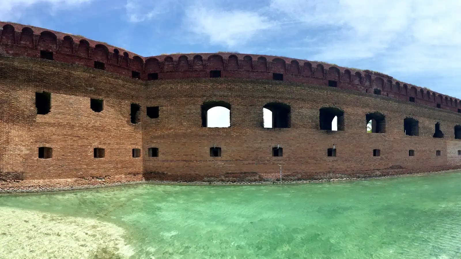
A low historic brick fortification standing at the edge of calm coastal water
Frances Gunn francesgunn

Historic site

Fort Massachusetts

Last updated

A brick coastal fort on a barrier island, held during the Civil War by one of the first Black regiments in United States service.

The fort sits at the western tip of Ship Island with its curved brick face almost in the water, which is the first thing you notice and the first thing that tells you something. It was not built that close to the sea. The island has moved under it.

Masonry work started in 1859 as part of the last great programme of American coastal fortification — the same generation of forts as Sumter and Pickens — and was overtaken by the war it existed to prepare for. Mississippi troops held the half-finished works briefly under the name Fort Twiggs, then left. In July 1861 the guns on this island traded fire with a Union warship, the USS Massachusetts, in an exchange lasting about twenty minutes, and when the Union took the island for good the fort acquired that ship's name. Building carried on through the war and stopped in 1866, by which point rifled artillery had made brick coastal forts pointless. It never fired on the enemy fleet it was designed to stop.

What it did instead is the part worth the crossing. Ship Island became the Union staging base for the campaign that captured New Orleans, then a prison and a quarantine station. And its garrison included the Second Regiment of the Louisiana Native Guards — African-American soldiers, among the first Black regiments mustered into United States service, stationed on a sandbar in the Mississippi Sound guarding Confederate prisoners. Men who in many cases had been enslaved in Louisiana two years earlier stood watch over the Confederacy's captured soldiers here.

Inside, the casemates run in a curve of brick arches, dim and noticeably cooler than the sand outside, with the sound of the Gulf carrying through the embrasures. It is a small building and half an hour covers it. But on a coastline where almost every structure a visitor sees postdates 2006, standing inside something built before the Civil War is a genuinely strange and useful experience, and the story attached to it is better than the architecture.

Getting there and parking

The fort stands a short walk from the ferry pier at the western end of West Ship Island, so getting to it is the same problem as getting to the island: a boat, and there is no other way.

The scheduled option is the National Park Service concessionaire's passenger ferry from Jones Park in Gulfport, running roughly mid-March to the end of October, about an hour each way. From a Biloxi hotel that means a twenty-minute drive west along US 90 first, and people get this wrong every season by turning up at a Biloxi marina.

From the pier the fort is perhaps a hundred yards over packed sand and short boardwalk, and it is the first thing you reach. If you are landing by private boat on the north shore, it is the obvious landmark to walk towards.

There is no vehicle access of any kind on the island, no golf carts and no transport from the pier. Everything is on foot.

The garrison that history mostly left out

The Louisiana Native Guards began in New Orleans as a Confederate militia unit of free men of colour, was never armed or trusted by the state that raised it, and was reorganised after the city fell in 1862 into regiments of the United States Army. Those regiments were among the first Black units mustered into federal service in the Civil War, and unusually for the period some of their company officers were Black men.

The Second Regiment was posted to Ship Island. Their duty was garrison work on a barrier island with no fresh water, no shade and a fort still missing parts of itself, guarding Confederate prisoners in the heat, the mosquitoes and the fever seasons. It was not the front line and it was not comfortable, and it was performed under officers and a War Department that were arguing in public about whether such regiments should exist at all.

Two things are worth holding onto out there. The first is the geography: the men doing this were within sight of the Mississippi mainland, twelve miles from plantations still operating. The second is the chronology. This was happening while the question of whether Black men would be soldiers was still being decided, and the answer was partly decided by units like this one doing the work.

The Park Service interprets this history on site. If a ranger talk is running when you land, it is the reason to take it.

Finished in 1866, for a war that ended in 1865

Third-system forts were designed around a simple calculation: smoothbore cannon firing round shot could not break several feet of brick, so a masonry fort with guns in tiers could hold a harbour against any fleet. That calculation stopped being true during construction.

Rifled artillery, firing elongated projectiles with far more penetrating energy, arrived in quantity during the Civil War and demolished the assumption. Fort Pulaski below Savannah was reduced in about thirty hours in 1862 by rifled guns firing from a distance its designers had considered safe, and every masonry fort on the American coast was obsolete the day that news travelled. Work on Ship Island continued anyway, because unfinished federal works tend to get finished, and stopped in 1866.

So the building you walk into was already a museum piece when the last brick went in. That is not a reason to skip it. It is the reason the fort survives at all: nothing that came after had any use for it, so nobody knocked it down, rebuilt it or armoured it over. What stands is close to what was intended, on an island that has otherwise been repeatedly rearranged by storms.

The military afterlife was brief. Ship Island served as a coaling and quarantine station, the guns went, and the fort settled into being a very large brick object on a sandbar.

What you are actually looking at

Approach it from the pier and the shape reads immediately: a low curved scarp of red-brown brick with a tier of arched gun positions behind it, facing the channel it was meant to command. The curve is not decoration. It lets guns cover a wide arc of water from a short frontage.

Inside, the casemates are the thing. Brick vaults springing from brick piers, one running into the next, each with an embrasure looking out at the Sound. In July the temperature drop as you step in is startling, and the acoustics are extraordinary: a conversation at one end carries the length of the arcade.

Look for the brickwork itself. Different courses, different colours, different degrees of weathering tell you which parts went up before the war and which after it, and salt has been working on the seaward face for a hundred and sixty years. Iron fittings have rusted and stained the brick around them. The floor is sand in places.

Outside, walk around to the waterline and look at how close the Gulf is to the wall. The Park Service has fought erosion here for decades. The fort was built on an island; the island has since migrated and shrunk around it, and what protects the masonry today is engineering rather than geography. That contrast — a permanent building on an impermanent landform — is the most interesting thing about the site and nobody puts it on a sign.

Getting inside it is not guaranteed

Two gates stand between you and the interior, and the first is the boat. The fort is only reachable from the seasonal Ship Island ferry out of Gulfport, from a private boat or from a charter. No ferry, no fort.

The second is the opening pattern. The interior is opened on a limited schedule rather than all day, and recent postings have run Wednesday to Sunday across a short midday window in season. Land on a Monday or a Tuesday and you may find yourself photographing the outside of a locked building. Check the current pattern with the Park Service before you pick your sailing, particularly if the fort is the reason you are going.

When it is open, ranger-led talks run and are worth arranging your day around — this is a site where the interpretation does much more than the building. Allow twenty to forty minutes inside, longer with a talk.

Physically it is manageable for most people: the ground floor is broadly level, though the surface is uneven brick and sand and there are steps at the entrance. There is no lift, no lighting beyond daylight through the embrasures, and no facilities inside. The restrooms and the shade are back across the boardwalk at the swim beach.

Near Fort Massachusetts

Straight-line distances, so allow more on the road — the island is long and has one main parkway.

  • Park

    A wide empty stretch of pale sand running away beside shallow clear water with almost nobody on it

    Ship Island

    A barrier island twelve miles offshore with clear Gulf water, a brick fort, and an anchorage that shaped three centuries here.

    4–7 hoursThe island itself carries no entrance fee. Getting there does — the ferry is a ticketed service, and a private charter costs considerably more.0.7 mi away

  • Nature preserve

    A timber boardwalk curving through dense swamp woodland above still dark water
    Free

    Gulf Islands National Seashore — Davis Bayou

    The only piece of the national seashore in Mississippi with a road to it: oaks, boardwalks, a bayou and a staffed visitor centre.

    1–3 hoursFree to enter and to walk. Camping is charged.16.2 mi away

  • Nature preserve

    Aerial view of a narrow strip of undeveloped pale sand between green water and dense pine forest
    Free

    Deer Island

    Four hundred acres of state-owned pine and marsh a short paddle off the beach road, with no ferry, no dock and nothing built on it.

    2–5 hoursFree. The cost is the boat.13.4 mi away

  • Neighbourhood

    Rows of boats moored in a marina basin on flat water at first light with a low skyline beyond
    Free

    Gulfport

    Mississippi's second city, twelve miles west along the beach road, holding the Ship Island ferry, the airport and the aquarium.

    1–5 hoursFree to visit. Jones Park and the harbour cost nothing; the ferry, the aquarium and the casinos do not.12.4 mi away

Fort Massachusetts: common questions

Who was Fort Massachusetts named after?

A ship, not a state directly. The USS Massachusetts exchanged fire with the guns on Ship Island in July 1861, in an action lasting about twenty minutes, and the fort took the warship's name once the island was securely in Union hands. Before that, Mississippi troops occupying the half-built works had briefly called it Fort Twiggs. Neither name was chosen by the engineers who designed it.

Were Black soldiers stationed at Fort Massachusetts?

Yes. The Second Regiment of the Louisiana Native Guards, made up of African-American soldiers and including some Black company officers, formed part of the Union garrison on Ship Island. They were among the first Black regiments mustered into United States service in the Civil War, and their duties here included guarding Confederate prisoners. It is the most significant thing about the site and the National Park Service interprets it on the island.

Did Fort Massachusetts ever see combat?

Not in the role it was built for. Guns on the island traded fire with a Union warship in July 1861 while the fort was still unfinished, but it never fought the fleet action its designers envisaged. By the time masonry work stopped in 1866, rifled artillery had already made brick coastal forts indefensible. Its real service was as a Union base, a prison and a quarantine station rather than as a battery.

Can you go inside Fort Massachusetts?

Usually, but not always, and not on every day of the week. The interior opens on a restricted seasonal pattern — recent postings have run Wednesday to Sunday across a short midday window — while the exterior can be walked around whenever the island is reachable. Since the only public access is the seasonal ferry from Gulfport, check both the sailing schedule and the fort's current opening days before you commit to a date.

How long do you need at Fort Massachusetts?

Twenty to forty minutes for the building, longer if a ranger talk is running and you should take it if one is. It is a compact single-tier fort rather than a sprawling site, and most visitors do it first thing after landing, then cross the boardwalk to the Gulf-side swim beach for the rest of the day. Allow extra time for the exterior walk round to the waterline, which is where the erosion story is visible.